Section 01
Strategic Position
Geography, the Strait of Gibraltar, and east-west shipping lanes — the geographic basis of the port's commercial role.
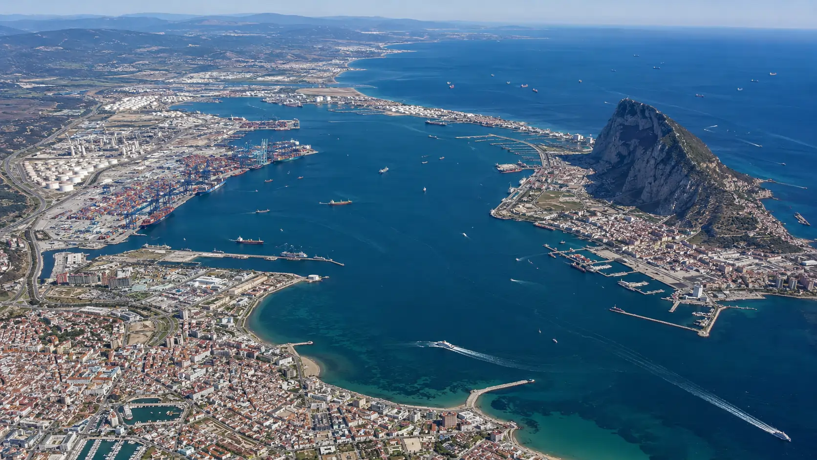
The Port of Algeciras occupies the western shore of the Bay of Gibraltar, on the Andalusian coast of southern Spain. Its commercial significance derives from a single geographic fact: the port lies adjacent to the Strait of Gibraltar, the only natural maritime connection between the Atlantic Ocean and the Mediterranean Sea. Every container vessel transiting from Asia to Northern Europe by way of the Suez Canal, every tanker connecting the Black Sea to the Americas, and every roll-on/roll-off vessel linking Iberia to the Maghreb passes within fifteen nautical miles of the Algeciras quays.
The Strait of Gibraltar as a maritime chokepoint
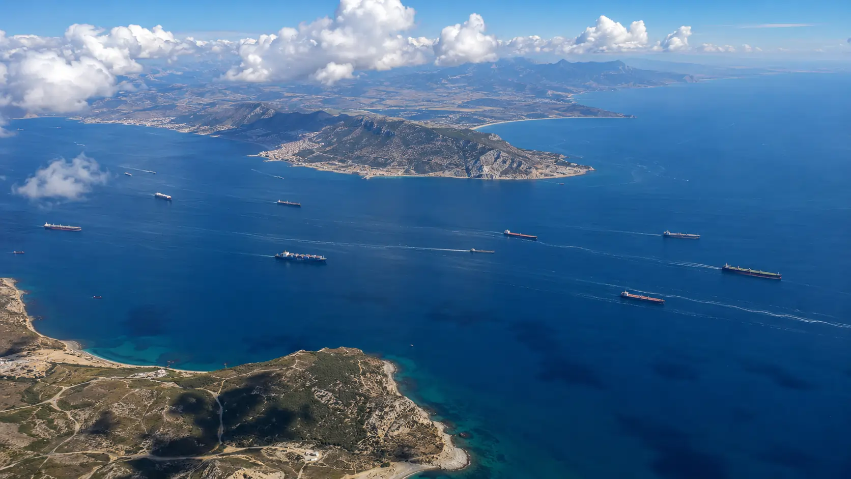
The Strait of Gibraltar narrows to approximately 14 kilometres at its tightest point, between Punta Marroquí on the Spanish side and Punta Cires on the Moroccan coast. Daily transits of the Strait number in the high hundreds: a continuous procession of east-west shipping that includes ultra-large container vessels of more than 18,000 TEU capacity, very large crude carriers (VLCCs) bound for European refineries, and the dense ferry traffic that connects the European and African continents at their nearest approach.
For a transshipment port, proximity to such a corridor is the principal commercial asset. A container vessel of more than 20,000 TEU does not deviate from its scheduled route to call at a regional port unless the call adds little to its voyage time. The Port of Algeciras offers what the industry terms a zero-deviation call: the port lies directly on the principal east-west sailing line, requiring no significant detour from a vessel's commercial route. Containers can be discharged at Algeciras for onward distribution by feeder vessels to Mediterranean and West African ports, and the deep-sea vessel resumes its trans-oceanic voyage with minimal delay.
The Bay of Gibraltar complex
The port designated as "Port of Algeciras" is not a single basin but a distributed complex of maritime infrastructure scattered around the Bay of Gibraltar (the Bahía de Algeciras in Spanish; the Bay of Gibraltar in English usage). Although only the municipalities of Algeciras and La Línea de la Concepción face the open bay directly, port facilities also belong administratively to San Roque and Los Barrios — three further municipalities that share the bay's coastline.
Across the bay, dominating the eastern shore, stands the Rock of Gibraltar — the British Overseas Territory whose own port and bunkering operations have, since the early twentieth century, formed a complementary and at times competing presence to the Spanish port complex. The unusual political geography of the bay — Spanish facilities on three sides, British territory on the fourth — has shaped the development of Algeciras itself. Twentieth-century investment in the port intensified under the Franco regime as a means of absorbing Spanish labour displaced when the border with Gibraltar was closed in 1969.
The principal sub-facilities of the bay complex, all under the management of the Autoridad Portuaria Bahía de Algeciras (APBA), include the historic Algeciras port at the mouth of the Río de la Miel; the Isla Verde Exterior expansion, which hosts the TTI Algeciras container terminal and the EVOS Algeciras fuel storage installation; the Campamento port facilities at San Roque, designed under a sustainable industrial development model; and a number of specialised installations including the Cepsa refinery jetty and the Acerinox stainless steel works berth.
East-west and north-south shipping flows
The transshipment role of the Port of Algeciras rests on two distinct shipping flows that intersect at the Strait. The dominant flow is east-west: containerised cargo moving between Asian production centres and European or American consuming markets, with the great majority of this traffic transiting the Suez Canal and entering the Mediterranean from the east. The principal shipping lines serving this corridor — Maersk Line, MSC, CMA CGM, and the consortia they operate within — schedule weekly services that connect the Far East, the Middle East, and South Asia to Northern European ports such as Rotterdam, Antwerp, and Hamburg.
The secondary flow is north-south: a denser web of regional shipping connecting Iberia and southern Europe to the ports of North and West Africa. This includes the heavy ferry traffic across the Strait itself, the feeder services that distribute Algeciras-discharged containers to Moroccan, Algerian, Tunisian, and West African ports, and the breakbulk and project cargo that supports African industrial development.
The combination of these two flows is the operational basis of the port's competitive position. A container discharged from an Asia-Europe service in the morning can be loaded onto a West African feeder by the same evening; a Moroccan trailer driver delivering goods to Tangier in the morning can be at a Strasbourg distribution centre within forty-eight hours.
Competition: Tanger Med
Across the Strait, the Moroccan transshipment complex at Tanger Med has, since its inauguration in 2007, become the principal commercial competitor to the Port of Algeciras. Tanger Med occupies a geographically equivalent position on the Strait's southern shore, offers comparable nautical access for deep-sea container vessels, and operates under a regulatory and labour regime that is in several respects more flexible than the Spanish framework. The two ports have, since approximately 2010, traded the position of leading Mediterranean container hub between them.
For the period under review in this Handbook, Algeciras retained the leading position in the Mediterranean by total tonnage and held a marginal lead in container TEU throughput. The competitive dynamic between the two ports is treated in greater detail in Section 9 (Statistical Annex), where comparative ranking data are provided.
Editorial Note · 2026
By the early 2020s, Tanger Med had overtaken Algeciras in container TEU throughput, becoming the leading Mediterranean container port. Algeciras retains its lead in total tonnage and remains the largest port in Spain by overall cargo volume. The competitive dynamic across the Strait has, over the intervening period, sharpened into one of complementary specialisation rather than direct rivalry.
Climate and operational conditions
The Bay of Gibraltar is sheltered from the open Atlantic by the geography of the Strait itself, but is exposed to the Levante and Poniente — the easterly and westerly winds that channel through the Strait with characteristic intensity. Levante winds, particularly during the summer months, can reach sustained velocities sufficient to suspend certain pilotage operations and to delay container handling on the most exposed berths. The port records, on average, between eight and fifteen days per year on which Strait-related weather imposes operational restrictions.
Tidal range in the bay is modest by Atlantic standards — typically less than one metre on spring tides — and presents no operational constraint to deep-draft vessels. The water depth at the principal container berths permits the accommodation of ultra-large container vessels at all states of the tide.