Port Profile
Port of Algeciras
Spain's largest port by tonnage, the leading container hub on the Mediterranean, and the principal European gateway to North Africa across the Strait of Gibraltar.
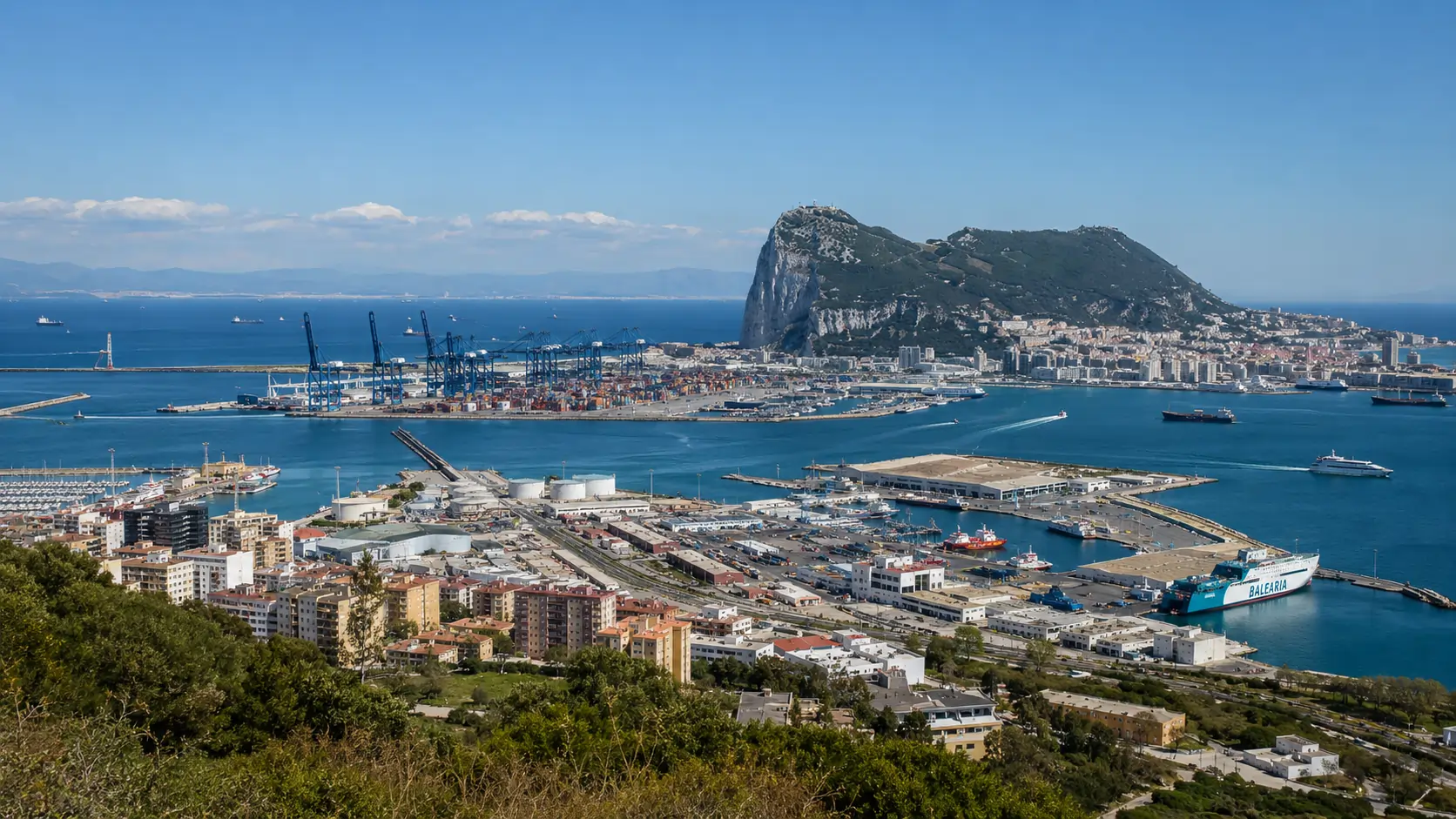
The Port of Algeciras — formally the Algeciras Bay port complex — occupies the western shore of the Bay of Gibraltar on the southernmost coast of Andalusia. Within a decade of intensive expansion that closed in the late 2000s, the port emerged as the largest in Spain by total tonnage and a leading Mediterranean container transshipment hub. Its commercial role is structured around a single geographic fact: position adjacent to the Strait of Gibraltar, the only maritime corridor between the Atlantic Ocean and the Mediterranean Sea.
Geography and setting
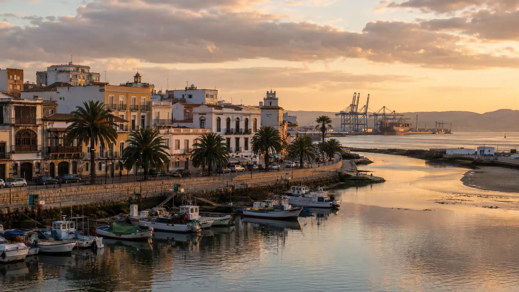
The Bay of Gibraltar (Bahía de Algeciras in Spanish; Bay of Gibraltar in English nautical usage) is enclosed by the Iberian Peninsula on its western, northern, and eastern shores, with the Strait of Gibraltar forming the open southern boundary. The Spanish municipalities of Algeciras, Los Barrios, San Roque, and La Línea de la Concepción surround the bay; the British Overseas Territory of Gibraltar occupies the eastern shore. The port complex itself is distributed across the Spanish municipalities, with the historic core at the mouth of the Río de la Miel in the Algeciras municipal centre.
The marine environment of the bay is, by Mediterranean standards, biologically rich. Multiple species of cetaceans transit the Strait of Gibraltar — including common dolphins, striped dolphins, bottlenose dolphins, long-finned pilot whales, sperm whales, and seasonally fin whales and orcas. The interaction between the bay's working port and its marine biodiversity is one of the recurring themes of regional environmental discussion.
From Carteia to the modern port
Commercial maritime activity at the Bay of Gibraltar predates the modern port by approximately two thousand years. The ancient port of Carteia, founded by Phoenician traders and subsequently consolidated as a Roman colonial port from 171 BCE, occupied a site within the modern municipality of San Roque on the eastern shore of the bay. Carteia operated as a regional trading centre and Mediterranean tuna-fishing port for several centuries before declining with the broader collapse of Roman trading networks.
The medieval and early-modern port at Algeciras itself developed under successive Andalusian, Nasrid, and Castilian administrations. The historic settlement was destroyed in the Nasrid scorched-earth withdrawal of 1369; the modern town of Algeciras was re-founded in the eighteenth century, and the first significant modern port infrastructure — the wooden jetty at the mouth of the Río de la Miel — dates to 1894.
Modern industrial port development began in earnest in the 1960s, with intensified investment under the Franco regime following the 1969 closure of the Gibraltar border. The closure displaced Spanish labour and commerce that had been integrated with the Gibraltar economy; the port at Algeciras was developed in part to absorb this displacement and to assert Spanish commercial primacy in the bay. Container terminal development followed in the 1970s and 1980s, with the major expansion at Isla Verde Exterior completing in 2010.
The contemporary port
The contemporary Port of Algeciras handles approximately 107 million tonnes of cargo annually (as of 2020), including 5.1 million container TEUs. The port is the largest in Spain by total tonnage and competes with Tanger Med across the Strait for the position of leading Mediterranean container hub. Detailed terminal and operational information is recorded in the Port of Algeciras Handbook 2011 Edition, with comparative period statistics in the Statistical Annex.
Port management is exercised by the Autoridad Portuaria Bahía de Algeciras (APBA), a public body operating under the Spanish State Ports framework. APBA also manages the port of Tarifa, a small mixed commercial and ferry port at the southernmost tip of mainland Europe, approximately 25 kilometres west of Algeciras.
Climate and operational conditions
The Bay of Gibraltar experiences a Mediterranean climate moderated by Atlantic influence through the Strait. Summers are warm and dry, winters mild and damp. The Strait channels two distinctive wind regimes: the Levante (easterly) and the Poniente (westerly), both of which can reach sustained velocities sufficient to impose operational constraints at the port — particularly the Levante during summer months, which can suspend pilotage operations on a small number of days each year.
Strategic position and competition
The port's strategic position is treated in detail in Section 1 of the Handbook. The central commercial proposition is the zero-deviation call — a vessel transiting the Strait on its scheduled route can call at Algeciras with no significant detour, permitting transshipment without commercial cost in voyage time. The same proposition applies to Tanger Med across the Strait; the resulting competition has been the principal commercial dynamic of the Mediterranean transshipment industry since approximately 2010.
Further reading
- Port of Algeciras Handbook · 2011 Edition — full reference publication, ten sections
- § 1 Strategic Position — geography and east-west shipping flows
- § 2 Infrastructure — basins, quays, and terminal layout
- § 9 Statistical Annex 2010 — throughput and rankings
- Wikipedia · Port of Algeciras — encyclopaedic overview
- Autoridad Portuaria Bahía de Algeciras — official Port Authority